Home assignment 4
Contents
Home assignment 4#
Last updated: 2023-02-25 13:41:24
Question 1#
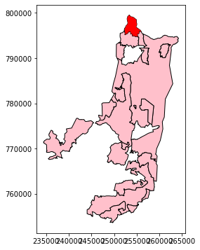
Read the towns (
muni_il.shp) layer (see Sample data).Aggregate the towns layer according to the
'Muni_Eng'column, to dissolve the separate polygons per town (see Aggregation (.dissolve)).Choose a city that starts with the same English letter as your first name (e.g.,
"Metula"if your first name is Michael).Create a subset of the
townslayer which includes the neighbors of (i.e., intersecting with) the town you selected.Plot the resulting layer, using different colors for the selected town and for the neighbors.
Note that you cannot specify any specific town names or indices other than the string with the name of the selected town (e.g.,
"Metula").
Question 2#
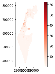
Calculate and plot the density (stops per \(km^2\)) of public transport stops (
stops.txt) per town (muni_il.shp). Go through the following steps.Read the towns (
muni_il.shp) layer (see Sample data).Aggregate the towns layer according to the
'Muni_Heb'column, to dissolve the separate polygons per town (see Aggregation (.dissolve)).Read the
stops.txttable and convert it to a point layer (see Table to point layer).Transform the stops layer to the CRS of towns (ITM).
Calculate the number of stops per town. Hint: use spatial join to join stops to the towns layer, then use aggregation to get a table of stop counts per town, and, finally, join the counts table back to the towns layer.
Calculate town area in \(km^2\), then divide the stop count by area to get stops density.
Plot the towns layer using using the
'Reds'colormap (cmap='Reds') with a legend (legend=True).
---------------------------------------------------------------------------
ImportError                               Traceback (most recent call last)
/tmp/ipykernel_13174/1173015350.py in <module>
     14 stops = stops.to_crs(towns.crs)
     15 # Calculate count per town
---> 16 stops = gpd.sjoin(stops, towns, how='left')
     17 stops = stops[['Muni_Heb', 'stop_id']].groupby('Muni_Heb').nunique().reset_index()
     18 towns = pd.merge(towns, stops, on='Muni_Heb', how='left')

~/.local/lib/python3.10/site-packages/geopandas/tools/sjoin.py in sjoin(left_df, right_df, how, predicate, lsuffix, rsuffix, **kwargs)
    122     _basic_checks(left_df, right_df, how, lsuffix, rsuffix)
    123
--> 124     indices = _geom_predicate_query(left_df, right_df, predicate)
    125
    126     joined = _frame_join(indices, left_df, right_df, how, lsuffix, rsuffix)

~/.local/lib/python3.10/site-packages/geopandas/tools/sjoin.py in _geom_predicate_query(left_df, right_df, predicate)
    214             # all other predicates are symmetric
    215             # keep them the same
--> 216             sindex = right_df.sindex
    217             input_geoms = left_df.geometry
    218

~/.local/lib/python3.10/site-packages/geopandas/base.py in sindex(self)
   2704                [2]])
   2705         """
-> 2706         return self.geometry.values.sindex
   2707
   2708     @property

~/.local/lib/python3.10/site-packages/geopandas/array.py in sindex(self)
    289     def sindex(self):
    290         if self._sindex is None:
--> 291             self._sindex = _get_sindex_class()(self.data)
    292         return self._sindex
    293

~/.local/lib/python3.10/site-packages/geopandas/sindex.py in _get_sindex_class()
     19     if compat.HAS_RTREE:
     20         return RTreeIndex
---> 21     raise ImportError(
     22         "Spatial indexes require either `rtree` or `pygeos`. "
     23         "See installation instructions at https://geopandas.org/install.html"

ImportError: Spatial indexes require either `rtree` or `pygeos`. See installation instructions at https://geopandas.org/install.html