
Home assignment 5
Contents
Home assignment 5#
Last updated: 2023-02-25 13:41:32
Question 1#
Import the following layers:
data/statisticalareas_demography2019.gdb—Statistical areas
output/sentinel2.tif—Sentinel-2 satellite imageRescale the raster values to the 0-1 range (see Rescaling) and calculate NDVI (see Calculating indices)
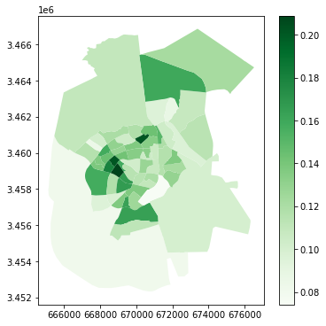
Calculate the average NDVI per statistical area in Beer-Sheva (
'SHEM_YISHUV'column =='באר שבע'), using zonal statistics (see Zonal statistics).Plot the layer of average NDVI in statistical areas of Beer-Sheva. Use the
"Greens"color map.Note: Do not re-create
sentinel2.tifin your code. Instead, import it fromoutput/sentinel2.tif.
Question 2#
Import the following layers:
data/muni_il.shp—Israel towns
output/sentinel2.tif—Sentinel-2 satellite imageAggregate the towns layer according to the
'Muni_Heb'column to dissolve the separate polygons per town (see Aggregation (.dissolve)).Calculate an attribute named
propwith the proportion of each towns’ polygon area that is within the extent of thesentinel2.tifimage (Stacking raster bands). For example, Beer-Sheva is 100% within the image (prop=1.0), Meitar is ~60% within the image (prop=0.6), etc. Hint: calculate the area of the original polygons, then calculate the area of the intersections (see Set-operations (.overlay)) with image extent polygon (see Raster extent), and finally divide the intersection area by the total area.Print the subset of towns layer where the proportion intersecting with the image extent is above
0, sorted by the proportion.Note: Do not re-create
sentinel2.tifin your code. Instead, import it fromoutput/sentinel2.tif.
---------------------------------------------------------------------------
ImportError                               Traceback (most recent call last)
/tmp/ipykernel_13193/3713045795.py in <module>
     12 bbox = bbox.to_crs(towns.crs)
     13 # Overlay
---> 14 towns1 = towns.overlay(bbox, how='intersection')
     15 # Calculate proportion of overlap
     16 towns['area'] = towns.area

~/.local/lib/python3.10/site-packages/geopandas/geodataframe.py in overlay(self, right, how, keep_geom_type, make_valid)
   2350         dimension is not taken into account.
   2351         """
-> 2352         return geopandas.overlay(
   2353             self, right, how=how, keep_geom_type=keep_geom_type, make_valid=make_valid
   2354         )

~/.local/lib/python3.10/site-packages/geopandas/tools/overlay.py in overlay(df1, df2, how, keep_geom_type, make_valid)
    315             result = _overlay_difference(df1, df2)
    316         elif how == "intersection":
--> 317             result = _overlay_intersection(df1, df2)
    318         elif how == "symmetric_difference":
    319             result = _overlay_symmetric_diff(df1, df2)

~/.local/lib/python3.10/site-packages/geopandas/tools/overlay.py in _overlay_intersection(df1, df2)
     28     """
     29     # Spatial Index to create intersections
---> 30     idx1, idx2 = df2.sindex.query_bulk(df1.geometry, predicate="intersects", sort=True)
     31     # Create pairs of geometries in both dataframes to be intersected
     32     if idx1.size > 0 and idx2.size > 0:

~/.local/lib/python3.10/site-packages/geopandas/base.py in sindex(self)
   2704                [2]])
   2705         """
-> 2706         return self.geometry.values.sindex
   2707
   2708     @property

~/.local/lib/python3.10/site-packages/geopandas/array.py in sindex(self)
    289     def sindex(self):
    290         if self._sindex is None:
--> 291             self._sindex = _get_sindex_class()(self.data)
    292         return self._sindex
    293

~/.local/lib/python3.10/site-packages/geopandas/sindex.py in _get_sindex_class()
     19     if compat.HAS_RTREE:
     20         return RTreeIndex
---> 21     raise ImportError(
     22         "Spatial indexes require either `rtree` or `pygeos`. "
     23         "See installation instructions at https://geopandas.org/install.html"

ImportError: Spatial indexes require either `rtree` or `pygeos`. See installation instructions at https://geopandas.org/install.html